I have a lot of flying dreams. They are so vivid that I swear my body remembers the sensation of flying (which is always like swimming through the air). My father's passion is flying airplanes. He wanted to be a fighter jet pilot and was forever scarred the day he was twelve and got eyeglasses. Even to this day my father is affected deeply by this turn of events in his life and still talks about how much he wished he could fly in a fighter jet, just once, and experience what it is like to do a roll in the air, just because you can.
As kids, my father would take us up in small two-seater airplanes and sometimes we would fly over our house. That was the coolest thing. A couple of years ago I went up in a helicopter for the first time at the helicopter museum in West Chester, Pennsylvania. My grandfather, who built and worked for helicopter companies the vast majority of his career, helped start the helicopter museum. That helicopter ride was an amazing experience.
I travel to Bend, Oregon many times a year. I usually drive except in the winter when conditions can be too wintry for such a long journye. A couple of weeks ago I flew from San Francisco to Bend. I love this flight because you fly in a small jet at such a low altitude that you can experience all the sights (and more) you see on the drive, from above. For me, it is magical. I hope you enjoy the journey in photographs. See the map below for a sometimes rough estimate of each photograph point.
View Larger Map
I turn on my DSLR the second after the attendant announces,
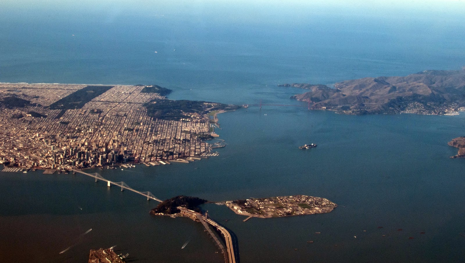
"It is now safe to use approved, electronic devices." This was the best shot of San Francisco I could get at this stage in the flight. I like finding my street and all the familiar places in the city. Here, you can see the long stretch of San Francisco beach, the Bay Bridge, the Golden Gate Bridge, the rectangular Golden Gate Park and Alcatraz, which looks much smaller than I pictured from the ground.
 |
| A: San Francisco, the Bay and the Marin Headlands |
We head north and east and pass over the East Bay where you can see Golden Gate Fields Racetrack, part of the Berkeley Hills, Richmond and towards San Rafael.
 |
| B: The East Bay |
 |
| C: Further north at the edge of the Bay, near American Canyon. |
|
|
It took me a little while to realize that this is Napa Valley. The rectangle at the bottom left corner is Yountville and the body of water on the right, center is Lake Hennessey. You can see north up the valley all the way to St. Helena. The vines would probably have leaves on them that have turned fall colors or maybe they have shriveled up by now.
 |
| D: Napa Valley |
This is the edge of Lake Berryessa where Berryessa-Knoxville Road crosses two bridges. The surrounding hills look relatively vacant over Napa County's largest lake.
 |
| E: Lake Berryessa |
Between Clearlake and Interstate 5 is this small mountain range. I drove through some of these hills last spring in search of wildflowers.
 |
| F: Hills East of Clearlake |
 |
| G: A valley somewhere in the hills west of Arbuckle. |
 |
| H: Hills and farmland north of Willows |
 |
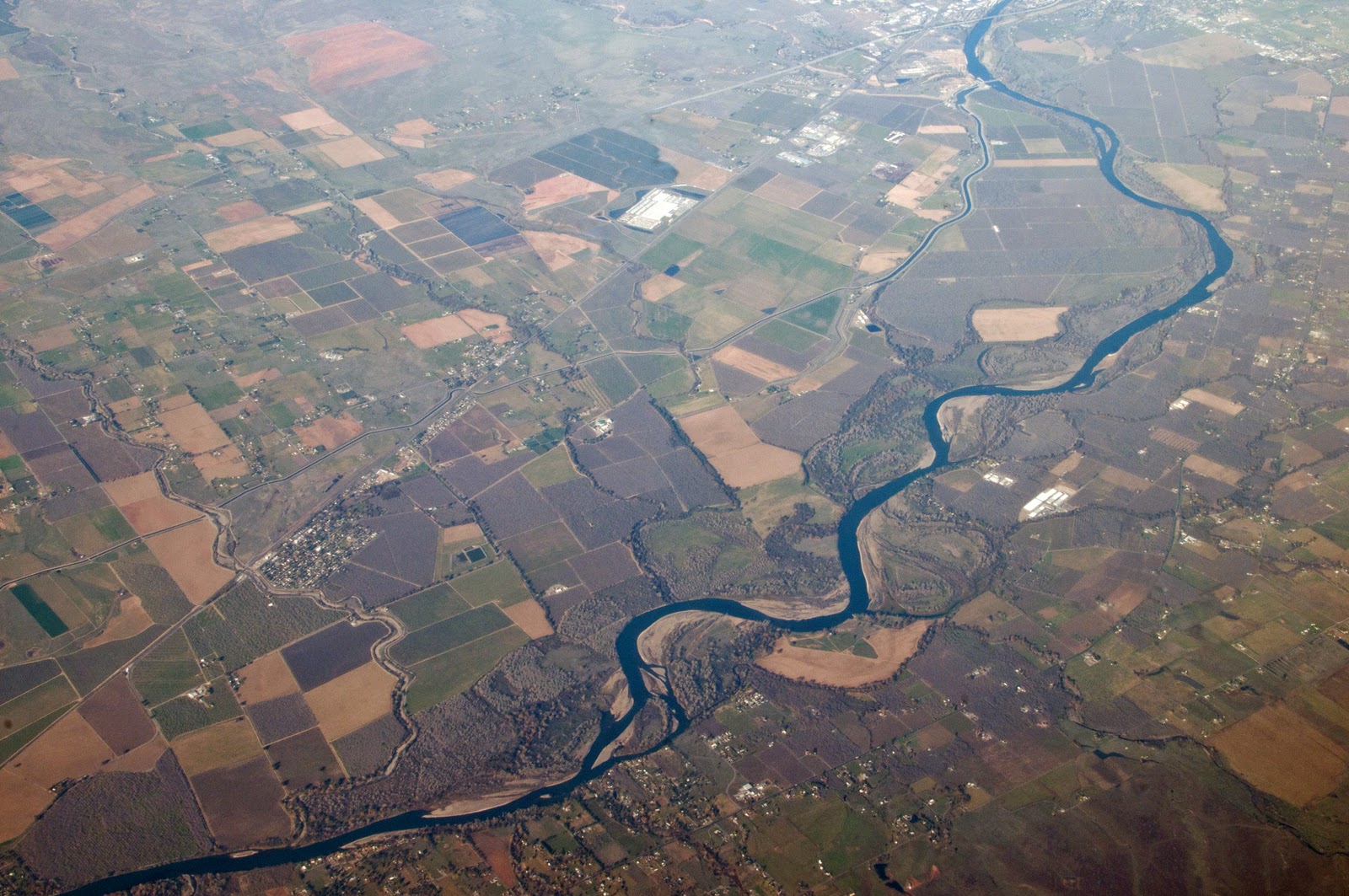
| I: The Sacramento River near the town of Proberta |
On my drives to Bend, I often get glimpses of the Sacramento River and I am always amazed at how long it runs. One of my favorite parts of the drive is around Lake Shasta. I always make my halfway stop in Redding for gas and a break. Then I get to enjoy the amazing scenery around the blue waters, mountains and inlets of Lake Shasta. I think it is actually more beautiful from the ground.
 |
| J: Lake Shasta, north of Redding |
When Interstate 5 gets to the town of Weed (yes there is a town called Weed) you get on Highway 97 to drive to Bend. This is where the drive gets really remote, but it is here that you are treated to the vistas of the looming Mount Shasta.
 |
| K: Mount Shasta |
 |
| L: Snow fields in the foothills of Mount Shasta |
 |
| M: Southeast of Macdoel at Robison and Technor Roads |
After leaving the hills around Mount Shasta you enter Butte Valley, a dry valley of irrigated farmland.
 |
| N: A view of the town of Macdoel and Meiss Lake in the distance |
|
Just over the Oregon border, the farmland changes a bit and you can see the difference a state funded irrigation program makes in the landscape.
 |
| O: Oregon farmland just over the border |
Continue on and soon you will be over the city of Klamath Falls, the first city since Redding.
 |
| P: Just north of Klamath Falls, the Upper Klamath Lake |
 |
| Q: West of Chiloquin on Sprague River Road |
The most amazing sight for me on the whole trip was seeing Crater Lake from the plane. It was truly amazing. When you visit the lake and look down from the rim, it feels like you are looking so far down. I never realized that the surface of the lake is actually at such a high elevation.
 |
| R: Crater Lake |
Between Crater Lake and Bend, there is a lot of pine forests and then lava fields. The most striking thing in Bend is the view of Mount Bachelor and the Three Sisters, one of my favorite vistas!
 |
| S: Mount Bachelor and the Three Sisters |


wow thank you for sharing this amazing(!!!!!) journey!
ReplyDeleteThanks for reading!
ReplyDeleteThanks, great post. Sets the place for further adventures perfectly.
ReplyDelete